Lake County Alleged Murphy Deed Reservations
Lake County
What is a Murphy Deed?
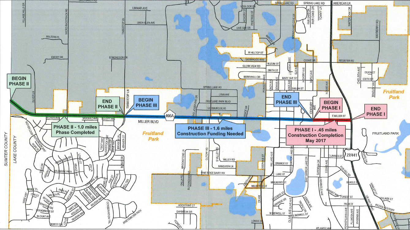
For the past several years, Lake County has been widening CR 466A from the Sumter/Lake County line and US 27. In order to widen this section of CR 466A, Lake County has had to utilize property adjacent to the roadway. In a number of instances, Lake County has told the owners of property adjacent to CR466A, that while Lake County would be using a portion of their property to widen CR 466A, Lake County would not be compensating the owner for its use of the owner’s property. Lake County has contended that it does not need to provide compensation for the use of certain owners’ property because of a 200 foot wide reservation along CR 466A created by multiple 1940’s Murphy Deeds.
So, what exactly is a Murphy Deed? Starting in the late 1920’s and extending through the 1940’s, the State of Florida took possession of hundreds of thousands – if not millions – of acres of property all across the State that had been abandoned by private owners due to the Great Depression. Eventually, the State’s legislators decided that rather than allow the State to maintain ownership over all the acquired property, it would be better to allow private individuals to purchase – and pay taxes on – the State’s recently acquired property for pennies on the dollar. The mechanism by which the State elected to convey its acquired property to private buyers came to be known as a “Murphy Deed”, so named after the Murphy Act (Chapter 18296, Laws of Florida, 1937) which created the conveyance mechanism. These Murphy Deeds conveyed ownership of tracts of land, formerly owned by the State, to private purchasers in fee simple, subject to certain reservations. These reservations would eventually allow the State to construct necessary public improvements (i.e. roads, canals, etc.) over Murphy Deeded property as the State’s population grew, without having to pay the owner of the property the compensation otherwise mandated by the State Constitution.
How Does this Affect Lake County Property Owners and What Can Be Done?
Our research indicates that multiple parcels of real property along CR 466A between the Sumter/Lake County line and US 27, were likely once a part of several larger tracts of property owned by the State. Eventually, the State conveyed those large tracts of property to private purchasers via Murphy Deeds. The specific language of these Murphy Deeds held that the State reserved for itself a total of 200 feet of right of way lying equally on either side of the center line of any state road then in existence. In other words, the State wanted to make sure that it – or any governmental body which the State conveyed its interest to – could widen an existing roadway without having to compensate the owner of the surrounding property for which it had conveyed ownership over.
It is currently this firm’s position that many of the Murphy Deed reservations, on which Lake County has relied in coming to its above described position of non-compensation, are invalid. In short, this firm believes that during the early to mid-1940’s, when most of the Murphy Deeds to the subject matter properties were conveyed by the State, what is now CR 466A was not a state road. Why this is relevant is because the reservations in these early to mid-1940’s Murphy Deeds conditioned the reservation on what is now CR 466A being, at the time the Murphy Deed was conveyed, a state road. If CR 466A was not a state road at the time the Murphy Deed was conveyed, then no valid reservation to the State was created. If a court were to be persuaded as to the correctness of this firm’s above contentions, then Lake County would be obligated, under Florida law, to compensate the property owners for those portions of their property Lake County used to widen CR 466A.
If you believe you or someone you know may have been impacted by Lake County’s reliance on a Murphy Deed, please contact our offices at 407.228.9522 or email by clicking
HERE.

 Maguire Lassman Silberngael, P.A., a Florida law firm that represents property owners faced with the potential acquisition of their property through eminent domain, has access to governmental Right-of-Way maps. If you own property in a proposed project corridor and you have any questions or concerns regarding same or general eminent domain law, please contact Maguire Lassman Silbernagel, P.A.'s office by email at Ben@Maguire-EminentDomain.com or by telephone at (407)-228-9522.

 Maguire Lassman Silberngael, P.A., a Florida law firm that represents property owners faced with the potential acquisition of their property through eminent domain, has access to governmental Right-of-Way maps. If you own property in a proposed project corridor and you have any questions or concerns regarding same or general eminent domain law, please contact Maguire Lassman Silbernagel, P.A.'s office by email at Ben@Maguire-EminentDomain.com or by telephone at (407)-228-9522.
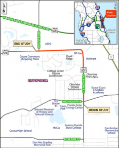 Maguire Lassman Silberngael, P.A., a Florida law firm that represents property owners faced with the potential acquisition of their property through eminent domain, has access to governmental Right-of-Way maps. If you own property in a proposed project corridor and you have any questions or concerns regarding same or general eminent domain law, please contact Maguire Lassman Silbernagel, P.A.'s office by email at Ben@Maguire-EminentDomain.com or by telephone at (407)-228-9522.
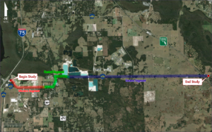
 Maguire Lassman, P.A., a Florida law firm that represents property owners faced with the potential acquisition of their property through eminent domain, has access to Seminole County’s Right-of-Way maps. If you own property in Seminole County that may be affected by the New Oxford Road construction and you have any questions or concerns about Seminole County’s recently released maps or Florida eminent domain law, please contact Maguire Lassman, P.A.’s office manager, Teri L. Alligood, by email at Teri@Maguire-EminentDomain.com or by telephone at (888) 216-6870.
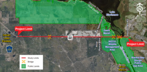 Maguire Lassman, P.A., a Florida law firm that represents property owners faced with the potential acquisition of their property through eminent domain, has access to Polk and Osceola Counties’ Right-of-Way maps. If you own property in Polk or Osceola County that may be affected by the SR 60 from CR 630 to E of Kissimmee River Bridge project and you have any questions or concerns about Polk or Osceola Counties’ recently released maps or Florida eminent domain law, please contact Maguire Lassman, P.A.’s office manager, Teri L. Alligood, by email at Teri@Maguire-EminentDomain.com or by telephone at (888) 216-6870.
 Maguire Lassman, P.A., a Florida law firm that represents property owners faced with the potential acquisition of their property through eminent domain, has access to Marion County’s Right-of-Way maps. If you own property in Marion County that may be affected by the NE 36th Avenue (NE 14th Street to NE 35th Street) expansion and you have any questions or concerns about Marion County’s recently released maps or Florida eminent domain law, please contact Maguire Lassman, P.A.’s office manager, Teri L. Alligood, by email at Teri@Maguire-EminentDomain.com or by telephone at (888) 216-6870.